Weekend snow possible across parts of North Georgia as arctic air and Gulf moisture converge
Forecast points to a narrow window for wintry precipitation
Parts of North Georgia could see light snow or a brief wintry mix this weekend as a cold air mass settles over the region while a developing system draws moisture east from the Gulf Coast. The setup is expected to create a tight temperature gradient, meaning small changes in storm track or surface temperatures could shift outcomes from plain rain to snow, sleet or freezing rain over relatively short distances.
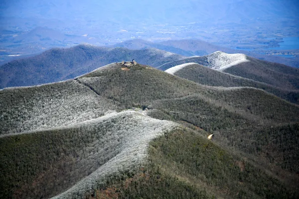
Recent forecasts have consistently indicated the greatest chance of measurable snow will be away from the urban core, with the highest elevations and areas northeast and east of metro Atlanta more likely to see flakes. In many locations, precipitation is expected to be light and short-lived, but even a minor accumulation can create travel hazards when road temperatures fall to or below freezing.
Where snow is most likely and what could limit totals
Potential accumulation is most closely tied to elevation and timing. The North Georgia mountains can cool more quickly at night and are more prone to a rain-to-snow changeover as colder air filters in behind a departing band of rain. In those areas, brief periods of light snow or a light mix may occur late Friday night into Saturday morning, and again as another disturbance moves through late Saturday into Sunday.
Moisture availability is a key limiting factor. Some forecast scenarios show the colder air arriving after the steadiest precipitation has already moved out, reducing the chance for meaningful snow totals. Other scenarios hold enough moisture in place for light accumulations, especially on grassy and elevated surfaces.
Impacts: roads, refreezing risk, and power considerations
Travel: Bridges, overpasses and untreated roads can become slick first, particularly if precipitation ends and temperatures drop quickly afterward.
Refreezing: Even if daytime temperatures rise above freezing, residual moisture can refreeze after sunset, creating patches of black ice into early morning hours.
Ice and outages: Widespread damaging ice is not currently the dominant signal for North Georgia in this setup, but any freezing rain in higher elevations can add risk for isolated tree and powerline issues.
What to watch through the weekend
Key forecast variables include the exact track of the surface low, the depth of subfreezing air near the ground, and the timing of the coldest temperatures relative to the heaviest precipitation. Residents in North Georgia—especially in mountain communities and locations northeast and east of Atlanta—should plan for rapidly changing conditions overnight and early morning, when freezing temperatures are most likely.
Winter weather outcomes in Georgia often hinge on small temperature differences that determine whether precipitation falls as rain, sleet, freezing rain, or snow.
Drivers should be prepared for localized slick spots, particularly before sunrise, and monitor any weekend advisories or warnings as forecast confidence increases closer to the event.