Snowfall totals across north Georgia to date show sharp contrasts between mountain ridges and metro Atlanta
What has fallen so far
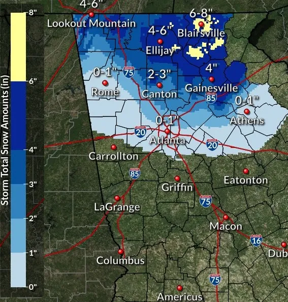
North Georgia’s winter season to date has produced uneven snowfall, with the largest accumulations concentrated in narrow corridors where heavier snow bands developed, while many communities only a short distance away recorded little more than a trace.
The most recent measurable snowfall in the region came with a late-January event that unfolded during the weekend of January 31–February 1, 2026. The system coincided with an intrusion of Arctic air and delivered a patchwork of outcomes across north Georgia: some counties recorded minimal accumulation, while others—particularly in the northeast and eastern portions of the state—reported multiple inches.
Preliminary reports from the January 31 event: a trace in some areas, several inches in others
Preliminary storm totals compiled from community and official reports show that parts of northwest Georgia saw only light snow. In and around Rome, reports ranged from a trace to about one-half inch, with nearby Calhoun around one-quarter inch. Polk County reports were largely a trace with localized totals near one-quarter inch, while Bartow County was generally around one-tenth of an inch. In northern Paulding County, reports reached up to about one inch.
At the same time, the event produced two more pronounced corridors of heavier snow across the northeast and eastern portions of Georgia. In those bands, totals commonly reached the 4- to 6-inch range, with some localized reports at or above that threshold.
Why totals vary so much in north Georgia
Snowfall in Georgia often depends on small shifts in storm track, the depth of cold air, and the timing of precipitation relative to the coldest temperatures. Even within the same county, elevation changes, local wind patterns, and the presence of heavier snow bands can lead to markedly different accumulations.
In the mountains, colder surface temperatures and higher terrain can sustain snow longer and support greater totals. In lower elevations and urban corridors, marginal temperatures and transitions between snow and mixed precipitation can limit accumulation or produce localized outcomes where snow briefly changes to sleet or freezing rain.
What residents can expect as totals are refined
Storm-total snowfall figures are typically updated as additional measurements are received, quality-checked, and incorporated into final event summaries. Reports submitted by trained observers and automated stations are commonly evaluated alongside public measurements and imagery to refine maps and totals.
- Totals may increase or decrease as late-arriving measurements are validated.
- Localized “bands” can create neighborhood-scale differences that may not be fully captured in early summaries.
- Final event documentation generally includes both snowfall and any ice accretion when relevant.
Storm-to-storm, north Georgia’s snow pattern often hinges on narrow bands of heavier precipitation—creating sharp differences between communities only miles apart.
This developing picture of snowfall to date underscores a recurring feature of Georgia winters: widespread headlines may accompany a system, but the final totals frequently depend on where the heaviest bands set up and how long surface temperatures remain cold enough for snow to accumulate.