North Georgia faces renewed weekend winter-storm threat as forecast models signal snow, ice risks
Another round of winter weather is possible as temperatures and moisture align
North Georgia could see a new winter weather episode this weekend as forecast guidance points to a cold-air surge arriving alongside moisture. The developing setup raises the risk of snow, sleet and freezing rain, particularly in higher elevations and along the Interstate 75 and Interstate 85 corridors, where small temperature changes can shift outcomes between rain, ice and accumulating snow.
Forecast confidence is typically highest in broad timing and lowest in exact precipitation type and accumulation totals. In this case, the key variables are how quickly subfreezing air settles into the region late Friday into Saturday, and whether precipitation arrives early enough to produce icing before a changeover to snow in colder areas.
What recent Georgia storms show about impacts
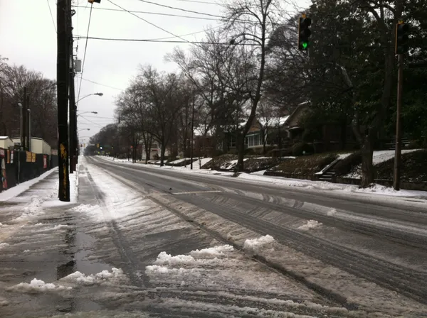
Georgia’s most recent high-impact winter event in January 2025 provides a practical reference point for how fast conditions can deteriorate when surface temperatures hover near freezing. During that storm, travel became hazardous on bridges, overpasses and untreated roads, and impacts persisted beyond the end of precipitation due to refreezing overnight.
Air travel disruptions were also significant during the January 10, 2025 event at Hartsfield-Jackson Atlanta International Airport, when heavy snow and deicing constraints contributed to widespread delays and cancellations. While this weekend’s forecast remains uncertain in magnitude, the prior storm underscored how quickly operational pressures can build when precipitation intensity exceeds expectations.
Transportation and emergency readiness typically focus on ice prevention
Road crews in metro Atlanta and North Georgia commonly rely on brine pretreatment to reduce ice bonding on pavement, applied in advance of anticipated winter precipitation. Even with pretreatment, officials regularly warn that secondary roads and untreated surfaces can remain slick, particularly if temperatures remain below freezing after precipitation ends.
Residents should be prepared for the most common winter-storm consequences in North Georgia: rapid changes in road conditions, localized power disruptions where ice or wet snow accumulates on trees and lines, and lingering hazards from overnight refreezing.
- Most likely travel hazards: bridges, elevated ramps, shaded routes, and untreated neighborhood roads
- Most likely timing for worsening conditions: late Friday night through Saturday morning, depending on temperature trends
- Most persistent risk after precipitation: refreezing where moisture remains on roadways
Forecast outcomes hinge on narrow temperature margins that determine whether precipitation falls as rain, freezing rain, sleet, or snow.
What to watch next
As the weekend approaches, the most decision-relevant updates will be changes in expected surface temperatures near daybreak Saturday, the projected rain-to-snow transition zone, and any winter storm watches or warnings that define the highest-risk counties. For North Georgia, even a modest shift in the storm track or cold-air timing can mean the difference between minor impacts and widespread travel disruptions.