Ice Storm Warning: Metro Atlanta Braces for a Dangerous Saturday Freeze
Morning: A Cold and Cloudy Start
Atlanta residents woke up to a gray and chilly Saturday morning as heavy cloud cover dominated the skyline. Early morning temperatures hovered around 42°F, though a light breeze made it feel closer to 38°F. While the first few hours of the day remained relatively dry, the high humidity of 61% and overcast skies served as a stark prelude to a significant winter system moving into the region. This brief window of calm is expected to end by midday as the atmosphere primes itself for an incoming winter storm.
Afternoon: The Transition to Sleet
As we move into the early afternoon hours, the weather is expected to take a sharp turn for the worse. Forecasters at the National Weather Service predict rain showers will begin before 1:00 PM, quickly transitioning into a messy mixture of rain and sleet as the mercury drops toward a daily high of only 40°F. East winds will pick up speed, sustained at 10 mph with gusts potentially reaching 20 to 30 mph. This cooling trend marks the arrival of a high-impact weather system that is expected to deteriorate road conditions rapidly across the metro area before the sun even sets.
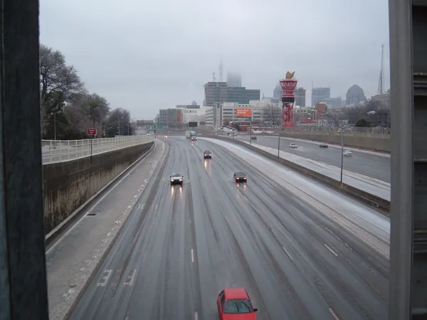
Evening and Overnight: Hazardous Icing Begins
The situation will likely become critical by Saturday evening. An Ice Storm Warning is officially in effect for metro Atlanta starting at 1:00 PM today and lasting through Monday morning. Temperatures are projected to plunge to an overnight low of 26°F, causing precipitation to transition fully into freezing rain and sleet. Experts are predicting a 100% chance of precipitation tonight, with total ice accumulations ranging from a quarter-inch to as much as one inch in some areas. This level of icing, combined with gusty winds, creates a high risk for widespread power outages and significant tree damage across North Georgia.
Official Alerts and Safety Precautions
In response to the severe weather threat, local authorities have issued several urgent notices for residents:
- Ice Storm Warning: Currently active for Fulton, DeKalb, Gwinnett, Cobb, and surrounding counties until 10:00 AM Monday.
- Travel Hazards: Bridges and overpasses are expected to freeze first. Officials strongly discourage travel, as roads may become impassable due to slick ice.
- Infrastructure Risks: Heavy ice accumulation on power lines and trees is likely to result in utility disruptions. Residents should prepare for extended periods without electricity.
- Emergency Supplies: Ensure you have non-perishable food, flashlights, and extra blankets. If you must be on the roads, carry an emergency kit including water and a flashlight.
Stay tuned to atlanta.news for live updates as we monitor this dangerous winter storm throughout the weekend.