Frosty Thursday: Atlanta Emerges from State of Emergency as Winter Storm Fern Exits
Arctic Air Settles Over the Metro as Storm Conditions Easing
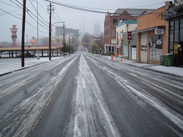
After a week dominated by the looming threats of Winter Storm Fern, Atlanta residents are waking up this Thursday, January 29, 2026, to a transition in weather patterns. While the immediate danger of heavy wintry precipitation has passed, the city remains gripped by a significant cold snap that has prompted state officials to maintain caution through the final hours of the current weather crisis. As the State of Emergency declared by Governor Brian Kemp officially expires today, the focus shifts from active precipitation to managing the residual impacts of sub-freezing temperatures.
Morning: A Frigid Start under Lingering Cloud Cover
The early morning hours in Atlanta are seeing temperatures hovering around a biting 30°F, with wind chill values making it feel closer to 25°F. Skies remain largely cloudy as the moisture from the previous system slowly clears the region. While the National Weather Service indicates a negligible 10% chance of isolated snow flurries or light rain during the morning commute, no significant accumulation is expected. Residents are advised to watch for slick spots on untreated surfaces and bridges, where moisture from earlier in the week may have refrozen overnight. Commuters should allow for extra travel time as city crews continue to monitor road conditions during the final stretch of the state-mandated emergency period.
Afternoon: Chilly Sunbeams and Highs in the 40s
As we move into the afternoon, the cloud cover is expected to break, giving way to periods of sunshine. Despite the sun, temperatures will remain well below the seasonal average, peaking at a high of approximately 46°F. Humidity levels are expected to sit near 52%, creating a dry, crisp cold. The gusty winds that characterized the earlier part of the week have begun to diminish, returning to more normal levels, though a light northerly breeze will keep the air feeling sharp. This afternoon provides the first real opportunity for residents to assess any minor damage from the week's wind and ice without the threat of new falling precipitation.
Evening: Clear Skies and a Sharp Overnight Drop
The evening forecast calls for a transition to clear skies, which will lead to a rapid drop in temperature after sunset. By late evening, the mercury is projected to fall back to a low of 29°F. With the lack of cloud cover to trap heat, the city is bracing for another night of hard freezes. This prolonged period of sub-freezing temperatures increases the risk of pipe bursts in residential areas. Authorities recommend keeping faucets at a slow drip and ensuring that all outdoor pets have adequate, heated shelter.
Safety Notices and State of Emergency Status
The statewide State of Emergency, which has been in effect since January 22 to address the impacts of Winter Storm Fern, is scheduled to conclude today, January 29. While state offices and local services are moving toward normal operations, the Georgia Emergency Management and Homeland Security Agency (GEMA) continues to urge caution. The primary hazards today are centered on cold-related illnesses and the potential for power outages if weakened tree limbs succumb to the previous ice weight. Residents are encouraged to remain vigilant, keep emergency kits stocked, and continue following the "People, Pets, Plants, and Pipes" protection protocols through the remainder of the week.