From Icy Grip to Arctic Chill: Atlanta Faces a Frigid Recovery as Winter Storm Fern Departs
Arctic Air Settles Over the Metro Following Major Ice Storm
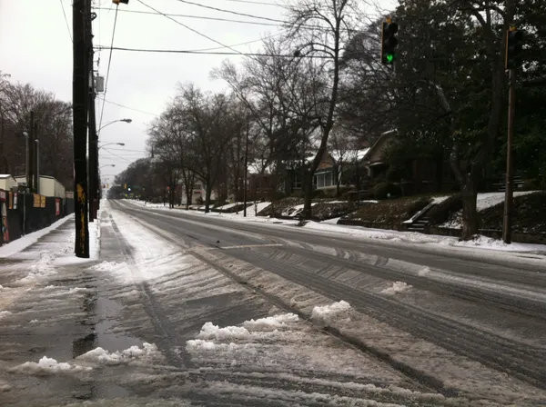
Atlanta residents are waking up to a transformed landscape this Monday, January 26, 2026, as the significant wintry precipitation from Winter Storm Fern moves out, leaving behind a layer of ice and a surge of dangerous Arctic air. While the heaviest freezing rain and sleet concluded overnight, the city remains under a State of Emergency declared by Governor Brian Kemp. The primary concern today shifts from active precipitation to the hazardous combination of sub-freezing temperatures and high winds that threaten to hamper recovery efforts and maintain treacherous road conditions through the morning commute.
Morning: Treacherous Roads and Bone-Chilling Winds
The early morning hours are critical for the metro area, with an Ice Storm Warning and a Cold Weather Advisory both in effect until 10:00 a.m. Temperatures at sunrise are hovering in the mid-20s, but with northwest winds sustained between 15 and 25 mph, wind chill values are dipping into the single digits and low teens. Authorities have reported widespread black ice on bridges and overpasses, leading to the closure of several schools and government offices across North Georgia. For those who must travel, extreme caution is advised as the morning sun may create a deceptive glare over icy patches that have not yet begun to thaw. Emergency crews continue to work on restoring power to the thousands of residents who lost service during the height of the storm on Sunday.
Afternoon: Sunny Skies Offer Little Warmth
As the day progresses, the thick cloud cover will give way to a mainly sunny sky. Despite the sunshine, the mercury will struggle to climb, with a predicted high reaching only between 32°F and 36°F. The persistent northwest winds, gusting up to 35 mph, will ensure that it feels significantly colder throughout the afternoon. While some minor melting may occur on sun-exposed surfaces, the Arctic air mass will keep most of the ice accumulation intact, especially in shaded areas and on secondary roads. Residents are encouraged to use this window of daylight to clear any debris or safe-to-reach ice from their property before the deep freeze returns after sunset.
Evening and Overnight: Record-Level Cold Intensifies
Conditions will become even more dangerous as the sun sets this evening. The sky will remain clear, allowing for maximum radiational cooling. Temperatures are forecast to plummet to a low of approximately 13°F to 15°F by late tonight. This extreme cold poses a severe risk for pipe bursts and cold-related illnesses. Residents are urged to keep faucets dripping and to ensure that pets and vulnerable neighbors are protected. Warming centers across the city, including those in Fulton and DeKalb counties, will remain open overnight to provide shelter for those without adequate heating or power.
Official Alerts and Safety Summary
- Ice Storm Warning: Remains in effect until 10:00 a.m. for significant icing and dangerous travel.
- Cold Weather Advisory: Active until 10:00 a.m. due to wind chills in the single digits.
- State of Emergency: Remains active statewide through Thursday, January 29, to facilitate disaster relief and utility repairs.
- Winds: Northwest at 15-25 mph with gusts up to 35 mph expected throughout the day.